 |
|
|
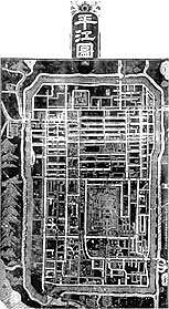 |
Map of the
Prefectural City of Pingjiang Southern
Song dynasty (1127�1279), Shaoding period (1228�33), engraved 1229 Drawn
by Li Shoupeng, engraved by Lu Ting and Zhang Yucheng Size
of the original stele: approx. 279.0 x 138.0 cm; height of rectangular portion:
approx. 198.0 cm; height of stele, including head: approx. 258.0 cm Re-engraved
in 1917 Hanging
scroll, ink rubbed on paper; 253.4 x 141.5 cm Date
of rubbing not given, Republican period, between 1917 and 1949 Inventory number:
221.201/1229/1139 This
map, engraved in 1229, is the oldest extant map depicting the city and superior
prefecture of Pingjiang (corresponding to present-day Suzhou).� One of the special characteristics of this
map is the use of uniform legends, which include both pictorial and graphic
types.� There are no fewer than 614
vertical or horizontal annotations on the map engraved in kaishu (regular script) of
varying sizes; nearly half of these are the names of bridges that span the
canals of this waterborne city, while others are the names of squares, temples,
monasteries, and other sites. The
map, which is highly comprehensive and accurately depicts the city as it stood
some fifty years before Marco Polo (1254�1324) is believed to have visited it,
has remarkably few omissions or mistakes.�
It was re-engraved in 1917 by Huang Weixuan under the supervision of Zhu
Xiliang and the distinguished bibliophile Ye Dehui (1864�1927), both natives of
Suzhou.� Rather than recarving the map
on a new slab of stone, the original stele was used.� The incised lines and legends, which had been worn away after
centuries of rubbings, were merely deepened, making possible the kind of
clarity seen here. |
 |