 |
|
|
 |
|
|
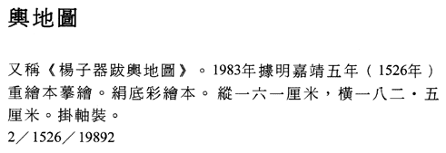
Map of Imperial
Territories Originally
drawn during the Ming dynasty (1368�1644), Jiajing period (1522�66), dated
1526; postscript by Yang Ziqi (1458�1513) Modern
copy of original made in 1983 Hanging
scroll, ink, color, and white pigment on 2 widths of silk stitched together;
160.2 x 182.6 cm Inventory number: 2/1526/19892 This
is one of the finest Ming maps showing political and administrative
divisions.� The original version, drawn
in color on silk around 1512 or 1513, is lost.�
A reworked version, based closely on the original was made in 1526 and
bearing a long colophon by Yang Ziqi (1458�1513), is now in the collection of
the L�shun Museum.� The National Library
of China's hand-drawn copy of the 1526 map was made in 1983. The
map provides at a glance the territorial scope and divisions of the Ming
Empire, whose external borders are demarcated by a red line, as are provincial
boundaries.� Although no explicit scale
is stated, the shape of the coastline, courses of rivers, political
subdivisions, and locations of administrative seats are relatively accurate,
suggesting that the original map was drafted according to some kind of
scale.� Using traditional Chinese
cartographic conventions, the network of rivers and waterways is
comprehensively shown and the sources of a number of rivers are provided.� Topographical features, historic sites, and
scenic spots are indicated pictorially.�
Cities and towns are white, the provincial capitals are red circles,
while the imperial capital Shuntian (modern Beijing) and the secondary capital
Yingtian (modern Nanjing) are prominent as the yellow octagons with red
borders.� The map�s more than 2,000 annotations
are supplemented by Yang Ziqi's colophon. |
 |