 |
|
|
 |
|
|
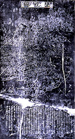
Geographic Map Southern
Song dynasty (1127�1279), undated, ca. 1190, engraved Chunyou period (1241�52),
dated 1247 Drawn
by Huang Chang (1146�94), ca. 1193; engraved on stone stele by Wang Zhiyuan
(1193�1257) in 1247 Dimensions
of original stele: 202.3 x 105.0 cm, 108.8 cm at the base Hanging
scroll, ink rubbed on paper; approx. 183.9�184.2 x 101.0 cm Date
of rubbing not given, Republican period, between 1911 and 1949 Inventory number: 2/1187/2/5022 The
scholar and imperial tutor Huang Chang drew this map around 1190 as one of
eight cartographic works presented to Zhao Kuo, the prince of Jia, who
subsequently ascended the throne as the Southern Song emperor Ningzong
(1168�1224; r. 1195�1224).� The map
shows the lu
(circuits), fu
(superior prefectures), jun (military prefectures), and zhou
(ordinary prefectures) in the Southern Song territories.� On the one hand, the map was produced as a
didactic tool to illustrate the loss of large territories to the Jurchens, who
established the Jin dynasty (1115�1234), including the Northern Song capital of
Kaifeng, the Yellow River basin, the Great Wall, and "a vast forest
stretching several thousands of li."�
On the other hand, it was designed to impress upon the future sovereign
that he had a responsibility to reclaim those lands for the Chinese Empire. The
first character of the map's elegantly engraved title at the top is pronounced zhui;
it is an archaic version of the character di. |
 |