 |
|
|
 |
|
|
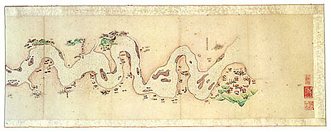
Map of Scenic
Attractions Along the Yangzi River Qing
dynasty (1644�1911), undated, believed to date to 1867 Illustrated
by Feng Shiji Album of 68 leaves mounted as a handscroll; first frontispiece section by Ouyang Zibin in ink on pale pink paper; 25.3 x 60.3 cm; second frontispiece section by Feng Shiji in ink on paper: 25.3 x 30.3 cm; map section in ink and light color on paper: 25.3 x 1120.6 cm; colophon section by Feng Shiji in ink on paper: 25.3 x 592.8 cm Inventory number:
074.2/(22)/1867/7474 At
5,550 kilometers, the Yangzi River is the longest in China as well as Asia, and
the third-longest in the world. It rises in the highlands between Tibet and
Qinghai and flows generally eastward through Tibet, Sichuan, Yunnan, Hubei,
Hunan, Jiangxi, Anhui, and Jiangsu provinces before discharging into the East
China Sea at Chongming Island, near Shanghai. This
unique sightseeing map of the river was painted in pale, subtle colors by Feng
Shiji of Shanyin during mid-autumn 1867.�
Originally folded accordion-style into a convenient size, its 68 leaves
are now stretched out as a very long handscroll, graced with a frontispiece
inscription in large characters by Ouyang Zibin.� It covers the middle and lower reaches of the Yangzi River from
Shishou County, Hubei, in the west to Jiangyin County, Jiangsu, in the east;
this stretch of the river has a great number of significant historic and scenic
sites along its banks.� Unrolling the
handscroll from right to left, the south bank of the river is at the top and
north bank at the bottom.� Just as the
river's scenery can be enjoyed from both sides of a boat, the map can be read
from either the top or bottom edge, depending on whether the user is going
upstream or downstream, and which side of the river is being observed. |
 |