 |
|
|
 |
|
|
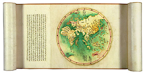
Coastal Map of
the Seven Maritime Provinces of the Illustrious Dynasty Qing
dynasty (1644�1911), Jiaqing period (1796�1820), dated 1798 Handscroll,
ink, color, and gold on paper; 29.2 x 888.9 cm Inventory number:
068.2/(2)/1798/6798 The
seven maritime provinces referred to in the title of this map are Shengjing
(roughly corresponding to modern-day Liaoning), Zhili (modern Hebei), Shandong,
Jiangsu, Zhejiang, Fujian, and Guangdong.�
This 1798 map is one of many based on the Yanhai quan tu (Complete
Coastal Map) drawn by Chen Lunjiong in the early Yongzheng period between 1723
and 1730.� Like Chen's prototype, this
map has six sections: a map of the Eastern Hemisphere, a coastal map of China,
a map of Taiwan, a map of the inner mountains of Taiwan, a map of the
Pescadores (Penghu liedao), and a map of Qiongzhou (Hainan). The
handscroll opens with an explanatory narrative followed by five separately
listed main points.� The circular map
depicts the eastern hemisphere with Japan and most of the Russian Far East,
part of Antartica at lower right, England at the upper left, the entire African
continent at left, and a number of archipelagos in the southern Atlantic Ocean
at lower left.� Not surprisingly, China
occupies a central position, and its territory is greatly exaggerated in
relation to other countries; all its provinces as well as the imperial capital
are listed by name.� The didactic
purpose was clearly to reinforce China's pride during the height of its
territorial expansion and its self-perception as a world power.� The main portion of the map shows the
coastline and immediate hinterland of the seven maritime provinces, beginning
with Shengjing in the north and continuing through Guangdong in the south but
horizontally oriented to accommodate the handscroll format.� Detailed geographical and narrative
descriptions are inscribed in neat blocks of text of varying lengths within the
blank spaces. |
 |