


A Study Guide About Dance, Ecology, and History "
Part II.
Of Rice and Rivers
Multicultural Education Curriculum
(Cambodia and Southeast Asia)
I. Suggested Activities and Classroom Strategies
(return to table of contents/next section)
Overall Objectives for Classroom ActivitiesOverall Objectives for Classroom Activities
1) The Mekong and Riverine Communities of Southeast Asia
2) Wet-Rice Cultivation
3) Sustainable Development and Environmental Advocacy
Development of knowledge of societies and environments
Development of key concepts:
* Time, Continuity and Change - Interpretations and Perspectives Development of skills for investigation, communication and team participation.
* Place and Space - Features of places, People and places, Care of places
* Culture - Cultural cohesion and diversity, personal, group and cultural identity
* Resources - Use of resources, People and work, Management and enterprise
* Economic and Social Systems
Development of critical thinking
Development of analytical thinking and skills
Development of appreciation for diversity and inter-connections
Development of an understanding of decision and policy making processes
Development of skills for independent learning
Development of skills for cooperative learning
Development of
- sense of interdependence1) The Mekong and Riverine Communities of Southeast Asia
- global awareness
- social responsibility
A. Waterways and societySuggested Activities
B. Student portfolios
C. Student-led water ecology curriculum
Using both of the maps enclosed in the packet, ask students to
1 Locate the Mekong River and other significant bodies of water in Cambodia.B. Student Portfolios2 Trace the Mekong, its source and courses as it traverses the many countries of Asia
3 Research and discuss the importance of rivers and water bodies to the people and society of Cambodia (and Southeast Asia).
4 Research and discuss the potential of the worlds waterways to feed the world's population adequately and supply many other necessary resources.
What are some of the possibilities?5 read old travel logs of Mekong expeditions. Compare them with contemporary travel logs of the Mekong and riverine communities of Southeast Asia
What are the challenges and constraints6 compare and contrast the following in terms of
a) characteristics
b) local and global importance
c) tales, myths and legends-The Mekong and the Amazon (and respective communities)
- The Mekong and the Mississippi
After reading the introduction provided in the teachers notes (to be adapted to appropriate grade-level), students are asked to investigate and create their own portfolios on any of the following themes. Students can select any one of the topics listed below for in-depth exploration:
1. Agrarian lifeways and communities
- characteristics of a Cambodian village2. Cambodian / Southeast Asian Economy(ies) (crops, exports)- architecture (as it reflects usage of local resources, accommodation to local climate etc.)
- foods
- Cambodian social system:
social relations
belief systems
symbolism (of animal characters, names etc.)
calendar (lunar vs. solar)
- identify products found in local imports and department stores that are made in Southeast Asia3. Tales, myths and legends of the Mekong: - Select some tales, myths and legends from the Mekong communities - Identify common themes (how do they reflect local characteristics, norms, beliefs etc.) - Compare and contrast usage of symbolism - Compare origin stories from the Mekong and those from the Amazon (e.g. comparing different stories about river dolphins)- identify products found in local imports and department stores that are of raw materials found in Cambodia and other parts of southeast Asia
- research other agricultural products of Cambodia/ Southeast Asia
- types of crops- visit a local Cambodian/Southeast Asian restaurant.
- export to the US market (e.g. coffee from Southeast Asia, the significance of the term Java and coffee, prevalence of Southeast Asian products in our daily lives (cotton, textile, rubber, sugar, coconut etc.)
Identify herbs and other ingredients used in the cooking- visit local neighborhoods- identify herbs and vegetables that are grown in family gardens.
Investigate their nutritional and medicinal importance- Invite parents, community elders or herbalists to come and speak to the class
- Create a community herb garden
C. Student-led development of water ecology curriculum:
Students are asked to imagine themselves as an educator involved in the development of a curriculum on water ecology
1. Identify and list issues to be addressed in the curriculumProcess:2.Develop classroom activities around these issues
3.Identify and list resources needed
Field trips and research activities
-Class visits to local libraries Students can work independently or in small groups to develop posters and charts on butcher paper for classroom presentation.
-Class visits to local imports and department stores.
-Class visits to local Southeast Asian neighborhood and stores
Students can then re- group for sharing and discussion of findings
Suggested Activities
1. Students can investigate the following:
- process and method of wet rice cultivation2. Students can research and construct a typical Khmer village- social relations in a Cambodian village
- Varieties of rice and nutritional importance
- Symbolism of rice
- in ceremonies
- rituals
- dance
- How does the natural environment influence local architecture?3. Students can compare and contrast rice farming in the US and in Cambodia- How does the natural environment influence traditional clothing?
4. Students can investigate the theme of women and development in Southeast Asia
Process:
Class visits to local libraries and museums3) Sustainable Development and Environmental advocacy
Student interviews of Cambodian elders with agricultural backgrounds
Students can engage in individual or team project, constructing a Khmer village
Activities
1. Students can research the state and condition of the Mekong.
what are the potentials for development?2. Ecologically sustainable development is vital. Find out what ecologically sustainable development' means and why it is vital in any development project.
what are the current plans for development?
what are the concerns (implications for individual lives and for communities)?
What are some of the major environmental issues in Southeast Asia?
why should Americans be concerned about developments in Cambodia and other parts of the developing world?
3. Students can compare and contrast the threats to, and destruction of, the major bodies of water in Cambodia with those in other parts of the world
- compare the recent flooding of the Mississippi river with that of the Mekong, and linking it to ecological destruction4. Students can develop and implement an advocacy and public awareness campaign- compare ecological destruction of the Mekong and Tonle Sap to the Nile and/or Amazon
Explore links to important marine and environmental sites.Process
Select one issue and create a poster informing the public about it and suggesting strategies to address the challenges.
Extend the poster campaign to a global to promote awareness about the environment and about water ecology
Students are asked to break into two large groups.
Create round table discussions and brainstorming sessions
Break each large group into sub-committees to research, gather information and develop campaign strategies
In the smaller groups, students are asked to Re-group after focused discussion for sharing with the entire class
-- discuss selected issues.
-- record ideas on chart papers.
II. Selected Resources
(return to table of contents/next section)
Chandler, David The Land and People of Cambodia , HarperCollins 1991
Global Witness , The Untoucheables , A Briefing Document, December 1999
Meng Srun Sin Deforestation and Relationship to Flood in Cambodia (online article)
Tooze, Ruth Cambodia: Land of Contrasts, the Viking Press, 1962
USDA, 1980, Forestry Activities and Deforestation Problems in Developing Countries, 115 pages.
United Nations Disaster management Team, 2000, Cambodia Flood, 22 pages.
Global Awareness Reports-
Website Links:
1. Fishery:
http://www.spc.org.nc/coastfish
2. Women in development:
http://globaled.ausaid.gov.au/primary/issues/women2.html
(The Global Education website has a number of other case studies on women in development. Topics include women in development, women in agriculture, women and micro-credit and women and health.)
III. Teacher's Notes*:
(return to table of contents/next section)
Introduction
Agriculture
Crops
The Monsoon and Cambodias Economy, Social and Cultural Patterns
Ecological Destruction and Flooding
Fishery
Cambodia is a small country---about the size of the state of Missouri---situated in the heart of the Southeast Asian peninsula. Cambodia is a land of great contrasts. Its central region, a wide basin lying almost at sea level, is surrounded by mountains. Its weather changes sharply from a bleak, dry season to a steaming moist season. The life blood of Cambodia is the mighty Mekong River, fourth longest river in the world, which rises far up in the snow covered mountains of China and flows down through south China, Laos, Cambodia and Vietnam to the sea, where it fans out into a great delta not unlike that of the Mississippi. Like the Amazon, the Nile and the great Yellow River of China, it brings life to a country through which it flows. During the long winter, while the northern mountains are frozen and snow-covered, no water flows, and the fields of the southern lands lie sere and dry. There is little water in pools and streams. The rivers water level is so low that its banks rise like high bluffs on either side. The sun shines mercilessly down from a cloudless sky for about six months, from October through April. During this time there is nothing to do in the fields. There is little fishing in the low waters. . Then in May, cloud masses begin to form and move majestically across the sky, like great white mountains with shadows of gray and purple The total area of Cambodia is 181,035 Km2. Its population is estimated at 11.5 million. The bulk population is confined to the flat alluvial plains which are well suitable to intensive agriculture. The population density of this area is 318 per Km2. The coastal zone has a density of 60 per Km2. In the mountainous zone, the density can be as low as 1 per Km2 (Source: Meng Srun Sin, Deforestation and the Relationship to Flood in Cambodia) .
(Ruth Tooze, Cambodia: Land of Contrasts)
Cambodia occupies a significant portion of the lower Mekong basin. Some 86% of the total area of Cambodia is within this river basin constituting 25% of the basin total catchment area (Land Use Map of Cambodia, 1991). Like many other countries along the Mékong River, Cambodia is regularly subjected to inundation as water overflows the river in the form of flood during the monsoon season. The Great Lake or Tonlé Sap and the Mékong River are of primary importance for the navigation and the supply of fresh water fishes.
(Source: Meng Srun Sin, Deforestation and the Relationship to Flood in Cambodia)
Agriculture
(Return to Teacher's Notes index)
Agriculture plays the most important role in the economy and society of Cambodia. It accounts for about 45% of the countrys GDP and 70% of its labor force. Over 85% of the population live in the countryside. Though Cambodias natural conditions allow for year-round cultivation of many kinds of crops, rice production accounts for 89% of agricultural undertakings; of the latter, the traditional pattern of single, rain-fed crop per year is most commonly practiced.
 Available estimates of the Ministry of Agriculture indicated that Cambodia has about 4.5 million hectares of arable land, of which 2.7million hectares are considered reasonably suited for agricultural production. The soils are of varying quality and generally not fertile except in the regions of the central plain which are fed and seasonally flooded by the river systems of the Mekong and the Tonle Sap. About two-thirds of the paddy areas, however, are located on infertile, sandy alluvium.
Because of the presence of significant bodies of water such as the Mekong, the Tonle Sap and Bassac rivers, Cambodias potential for irrigation is rather significant. The challenges and costs of dam construction, necessary to tap this potential, however, are equally significant and continue to impede the countrys agricultural development.
Crops
(Return to Teacher's Notes index)
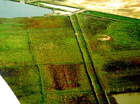
RiceBy July the fields are standing in water. Around each field is a ditch like a moat. A farmer hitches his wooden plow to two water buffalo to turn the heavy mud and prepare the field for planting the seedlings. Back and forth, back and forth the length of his fields, he clucks an calls to the slow-moving gray creatures as he ad they slosh knee-deep through the mud and water. Now and then birds come to rest on the spreading horns of the buffalo and take a little ride.
When the fields are plowed boys bring bunches of shoot from the seedbeds near their homes and stack them together near the center of each field. The women come and stand knee-deep in the water with backs bent as they transplant each single shoot from the seed bed to the thick, soft mud of the field (Ruth Tooze, Cambodia: Land of Contrasts)
Because of the fertility of the soil, the areas around the Tonle Sap (literally translated as the freshwater lake) and along the Mekong River are considered the countrys rice baskets. Rice production remains family-based subsistence farming, relying principally on family labor and, as such, is largely non-capital and technology intensive. The average landholding per farmer is estimated at 2-3 hectares, with 70% used for wet-rice cultivation. In addition to low access to fertilizer and appropriate seeds, water shortage, and innovative technologies, the smallness of the paddy size accounts partly for the relatively low average yield of 1-1.5 tons per hectare. In managed conditions, the average yield can reach 3 tons per hectare.
In December and January comes the harvest. The rice farmers use long, curved rice knives for harvesting. Each knife has a small sharp prong that cuts the rice on the forward swing and a large wooden curve that gathers a new bunch for cutting on the back swing. In the lowlands, the farmers carve the knife handles into the shape of the tail of a humpsa (sic), a mythical bird said to bring good luck to lowland rice growers. In the highlands, the farmers carve their knife handle into the shapes of dragons, said to bring good luck to rice growers there
When the rice stalks are cut, they are stacked in bunches for the rice to dry, and when it has dried, the heads are cut of. Then the women toss the whole rice grains in large, round woven bamboo trays, winnowing the kernels from the husks. Each family now has much of its reserve of food for the coming year. (Ruth Tooze, Cambodia: Land of Contrasts )
The Monsoon and Cambodias Economy, Social and Cultural Patterns
(Return to Teacher's Notes index)
The monsoon and Cambodias waterways, with outlets to the seas, are major factors affecting the countrys politics, trade and social development. The monsoon largely dictates the varieties of crops that could be planted as well as the planting seasons. In addition to wet-rice cultivation., Cambodias climate and soil condition are also suitable for the production of many other subsidiary crops. In the 1960s, 8% of the cultivated areas were used for the cultivation of corn, beans, sweet cassava, sweet potato, sesame and soy. Many of these crops, such as corn, were grown both for domestic consumption and for export. The river bank areas, with their rich soil, are most suited for these types of garden and orchard crops. The flooded forests near the Tonle Sap are especially conducive to bean production, although certain varieties of beans favor the upland red and black soils of Kompong Cham and Battambang provinces. Production of sweet cassava could be found in the red plateau soils of Kampot, south of Takeo and Kompong Cham provinces.
Local conditions are also suitable for fruit cultivation either on large plantations or on small-scale family farms. Banana, pineapple, mango, different varieties of citrus fruits, longan, rambuttan and durian rank among the more favored fruits, grown for both domestic and export markets. In addition, all throughout Cambodias countryside, sugar palm trees dotted the landscape. Production of palm sugar remains an important source of income for many farming families. Coconut is also an important crop, yielding many other important by products. Coconut milk is a key ingredient in Khmer cuisine and fresh coconut juice is one of the most nutritious and refreshing drinks for the tropical climate. In the pre-war years, coffee, of both the robust and arabica varieties, as well as jute and tobacco were among the nations exports. These agricultural sectors are being currently revived.
Because of Cambodias and Southeast Asias rich natural resources, trade and commerce within the region and outside of it have always been vital. Evidence has shown that trade with other centers of civilization such as Rome and Alexandria was already flourishing from the very first centuries, AD. Cambodias trade with India, particularly in gems and silk for the China market, had been the most sustained, resulting in significant cultural exchanges. Indian influence is still evident in the Khmer system of writing, religion, foods and many other cultural aspects.
The monsoon also influences many social patterns. Because of the centrality of rain in agrarian life, celebrations are often linked to nature s cycle and to the lunar calendar. The new year, for instance, is celebrated in April to coincide with the end of the harvest season and of hard work.
Ecological Destruction and Flooding
(Return to Teacher's Notes index)
Flooding of the Mekong has become increasingly more serious in recent years. The flood in 2000 was described as the worst recorded flood in Cambodia. Vast areas of the country remained submerged under water for many months. Assessment of damage was estimated as follows:
20 provinces affected.The frequency of major flood occurrence in Cambodia can be linked to the intensity of the rate of deforestation that is most evident since 1991. However, deforestation may not be the sole factor that causes the floods. Other factors, such as the amount of rainfall in each country, amount of rainfall at the source of River, and the number of dams on the Mékong River and its tributaries, may also contribute to the flooding along the Mékong River. (Source: .Meng Srun Sin, Ph. D. Deforestation and the Relationship to Flood in Cambodia)
US$ 50 million,
270 persons killed and 2.2 million affected
535,000 ha. of rice fields affected(Source: Meng Srun Sin, Ph. D. Deforestation and the Relationship to Flood in Cambodia):
Fishery *
(Return to Teacher's Notes index)
Fisheries in Cambodia play an important role in the national economy and in the provision of protein source in local diet. Main fishery sources are as follow:
Inland fisheries from the Tonle Sap (the Great Lake) and the Mekong river and its tributariesDuring 1960s, the average annual fish production was about 170,000 tons, of which 120,000 tons were from inland fishery, 45,000 tons from marine fishery and 5,800 tons from freshwater aquaculture. During the period of 1970 to 1975, fisheries management suffered serious setbacks. Political turmoil and internal disruption resulted in uncontrolled fishing activities in many open waters, including the use of destructive fishing gear and poaching. Fishery sources, especially in the Tonle Sap, were gravely damaged.
Freshwater aqua culture in the Tonle Sap and ponds
Marine fisheries from the coastal water
During the Khmer Rouge regime, which lasted from 1975 to1979, many factors contributed to the increased degradation of the lakes ecosystem. Several thousands of hectares of inundated forests were destroyed, accompanied by construction of irrigation dikes along the coast of the Tonle Sap and construction of irrigation barrages across rivers and streams which flow into the Lake. These developments resulted in large scale ecological damage. Furthermore, destructive fishing methods persisted in many areas and led to the destruction of numerous natural stocks of fish.
As a result of death and devastation, the Fishery Department had to be rehabilitated almost from scratch in the post-1979 period. This process, however, has been seriously challenged by the limitation in human resources and scarcity of technology, materiel and know-how. (Source: Japan- Cambodia Country Study).
* Statistical information drawn from Ministry of Agriculture of the Royal Kingdom of Cambodia, the Institute de Recherche et dEnseignement Forestier (IREF) with assistance from USAID, UN statistics and donor country studies. See also Meng Srun Sin, Ph. D. Deforestation and the Relationship to Flood in Cambodia)
IV. Cambodia: Country Facts
(return to table of contents)
Estimates for Y2000 *Capital: Phnom-Penh
Major Language: Khmer (sometimes referred to as Cambodian)
Population: 11.5 million
Urban areas: 13.5%Population Growth Rate**: 2.8%
Rural areas: 86.5%
Life Expectancy (years)**: 48
GDP ($million): 2,364
GDP per capita ($): 216
GDP Share:
Agriculture: 43%Adult Literacy Rate***: 60-70%
Manufacturing: 12%
Construction: 13%
Commerce: 10%
Others: 21%
Female Population: 60-65%
head of households: 25-40%Seasons
widows: 5-10%
Rainy: June-October* Estimates from ECFA Study Team
Dry: November- May
** Cambodia; Situation of Children and women, 1990, UNICEF
(Go to Part I)
(Return to Table of Contents)
(Move to top of page)