The Main Rongbuk Glacier, Mount Everest
Scroll over photo to study the loss of glacier mass between 1921 and 2007.
The surface area of glaciers in these high altitude valleys is often covered by layers of debris or snow. To determine the full measure of loss in the ice mass in these photos, look not only at how far the glaciers have receded, but at the surrounding valley walls. In many cases, the loss in depth is upwards of 300 vertical feet.
Understanding Scale

The dotted line shows the Main Rongbuk Glacier’s height in 1921. This photo from 2007 reveals a loss of 320 vertical feet in ice mass since George Mallory took the same photograph in 1921.

A detail of the yellow box is shown below.
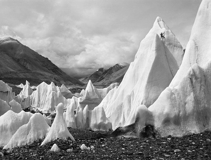
The climber (upper right) gives scale to the ice pinnacles, Main Rongbuk Glacier, Jimmy Chin, 2007. Courtesy of the artist.
[...] Rather than ancient snow pack, only an empty rock-strewn riverbed remains: the glacier has lost 320 vertical feet of ice mass in the intervening years in what researchers describe as a striking effect of global warming. (Roll your cursor over the images to get a sharper sense of the contrast here.) [...]
Pingback by Then and Now: The Vanishing Glaciers - Green Blog - NYTimes.com — July 15, 2010 @ 11:15 am
[...] Study the striking loss of glacier mass between 1921 and 2007 at AsiaSociety.org. “If current melt rates continue, these glaciers will be unable to maintain mass balance, ultimately disrupting the water supply to hundreds of millions of people downstream.” [...]
Pingback by On Thinner Ice – Melting Glaciers on the Roof of the World « I Count for myEARTH — July 15, 2010 @ 5:10 pm
[...] This post was mentioned on Twitter by Savil Srivastava, ZEROCO2. ZEROCO2 said: Interactif – Images superposées de l'Everest pour constater la fonte du glacier depuis 1921 (90 m) http://ht.ly/2c3Sm [...]
Pingback by Tweets that mention Rivers of Ice » Comparative Photography -- Topsy.com — July 15, 2010 @ 8:39 pm
[...] the Asia Society show he refers to. SHARETHIS.addEntry({ title: "Glaciers Dropping By Hundreds of Feet", url: [...]
Pingback by Glaciers Dropping By Hundreds of Feet | The Ruth Group — July 19, 2010 @ 1:50 am
[...] (An interactive graphic comparing the images is available.) [...]
Pingback by Melting Mountains | Entropy... — July 19, 2010 @ 4:41 am
[...] the Asia Society show he refers [...]
Pingback by Glaciers Dropping By Hundreds of Feet | All In One Boat — July 19, 2010 @ 4:48 pm
[...] are more photographs, here. They include a photograph from 1899 by Vittorio Sella, and 55-inch video displays of two [...]
Pingback by Computer Hardware News » Pictures show Everest’s vanishing glaciers — July 19, 2010 @ 6:57 pm
[...] Asia Society has a fascinating and alarming comparison of photos of the Main Rongbuk Glacier on Mount Everest taken in 1921 and 2010. The 2010 photo was [...]
Pingback by Private Health Insurance : : Daily Digest, 2010.07.19 - Insurance Today — July 20, 2010 @ 8:24 pm
[...] The melting glaciers of Mt. Everest are interesting, especially when you see the size comparison ima…. When I saw the first picture I have to admit I grossly midjudged the scale. [...]
Pingback by Friday Links: Surprise Edition — July 23, 2010 @ 1:48 pm
[...] amazing comparative photography shows the extent of glacial melt and loss of snow cover in the [...]
Pingback by Ben’s Blog » Blog Archive » Himalayan glacier melt photos — August 5, 2010 @ 2:33 pm
[...] di New York. Potete vedere alcune delle fotografie esposte nel bellissimo sito della mostra: https://sites.asiasociety.org/riversofice…. Attraverso la mostra, e più in generale attraverso il suo lavoro, Breashears vuole [...]
Pingback by Parliamo ancora di clima | Sofri - Corsi di geografia — September 15, 2010 @ 7:55 pm
[...] and cartographers, and then taking new photos of the same spots to compare the changes. In photo after photo, Breashears pointed to dramatic losses of glacier size and depth over a 100-year period. In one [...]
Pingback by Tragedy of the Commons: Himalayan Glacier Melt « The Dirt — October 19, 2010 @ 10:25 pm
[...] and cartographers, and then taking new photos of the same spots to compare the changes. In photo after photo, Breashears pointed to dramatic losses of glacier size and depth over a 100-year period. In one [...]
Pingback by Tragedy of the Commons: Himalayan Glacier Melt | Climate Himalaya Initiative — October 20, 2010 @ 11:31 am
[...] monk porters, he captures in stunning graphic beauty the glacial landscape. Breashears captures photographs from identical vantage points as past explorers such as George Mallory by retracing their steps. [...]
Pingback by Tibetan Plateau's Disappearing Glaciers Could Devastate Asia | Neon Tommy — November 19, 2010 @ 4:30 pm