 |
|
|
 |
|
|
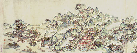
Complete Map of
the Sacred Peak of the South Qing
dynasty (1644�1911), undated, ca. 1908 Handscroll,
ink and color on paper; 31.8 x 210.0 cm Inventory number:
074.3/(226.51)/1908/2882 Mount
Heng, the sacred peak of the south,
was first mentioned in the ancient texts Shu jing (Book of Documents) and Zhou li
(Rites of Zhou).� Mount Heng is actually
a 400-kilometer-long range of 72 granite peaks stretching between Hengyang in
the south and Changsha in the north, towering above the low-lying Xiang River
valley.� The highest, the Blessed Fire
Peak, reaches an elevation of 1,298 meters above sea level. This
handscroll map takes the form of a traditional Chinese landscape painting.� Depicted from right to left (north to south)
are the provincial capital of Changsha, the county seat of Xiangtan, and
prefectural seat of
Hengzhou.� Among the scenic spots
identified are the Yuelu Peak across the Xiang River from Changsha; Shibing
Peak; Tianzhu Peak; the main cluster of peaks culminating in the Blessed Fire
Peak; the Mid-Mountain Pavilion; the Water Curtain Cave; the Temple of
Offerings; the South Terrace Monastery, first built in the sixth century; the
Guanyin Peak with a cave temple dedicated to Guanyin; and the Nine
Transcendents Monastery.� The most
prominent architectural feature on the map is the Temple of the Sacred Peak of
the South, one of the most magnificent in China.� First built during the Tang dynasty in 725 and expanded over the
course of the Song, Yuan, and Ming periods, it was destroyed by fire in the
late Ming.� Rebuilt in 1708, it again
succumbed to flames during the Tongzhi period (1862�74).� It is depicted on the map as it appeared
after the last rebuilding of 1882.� At
the end of the scroll is the prefectural seat of Hengzhou; a three-character
inscription on the lower edge denotes the eastern bank, reminding the viewer
that the peaks of Mount Heng are located on the western side of the Xiang
River. |
 |