 |
|
|
 |
|
|
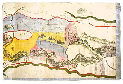
Map of the Routes
from Dajianlu to Anterior and Posterior Tsang Qing
dynasty (1644�1911), Guangxu period (1875�1908), dated 1901 Illustrated
by An Cheng Handscroll,
ink and color on silk; 41.4 x 316.3 cm Inventory number:
057.63/(227.003)/1901/0146 During
the Qing period, Tibet occupied a landmass considerably larger than its present
size and comprised four regions from east to west, namely Chams, �, Tsang, and
Ngari.� The vastness of Tibet's
territory and the great navigational difficulties it presented for travelers
made good route maps indispensable.�
This hand-drawn map is an excellent example of a Chinese route map
covering the distance between western Sichuan and the far west of Tibet. From
1696, Dajianlu (now Kangding in Sichuan), a walled town some 400 kilometers
southwest of Chengdu, was the one place where the Dalai Lama allowed Tibetans
to carry on trade and purchase bricks of tea leaves from growers in western
Sichuan Province; the town was also the center of Sichuan's thriving logging
industry.� The Chinese equivalent for �
is Wei, but the province was commonly called Qian Zang (Anterior Tsang), with
the capital at Lhasa.� Tsang, with its
capital at Shigatse, was known as Hou Zang (Posterior Tsang). Of
the three routes indicated on the map by short black parallel lines, the
northern one reaches farthest and terminates in Ngari.� The central route ends at Kyirong, and the
southernmost terminates at Nyalam.� A
bold red line indicates the border of Sichuan Province, while borders with
Yunnan Province, Nepal, Sikkim, Bhutan, Vietnam, Siam, the territory of
Xinjiang, and Russia are also indicated.�
Rivers and mountains are rendered in green, while plains and grasslands
are shown in yellow. |
 |