 |
|
|
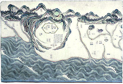 |
Geographical Map
of Taiwan Qing
dynasty (1644�1911), Qianlong period (1736�1795), undated, 1787 or earlier Handscroll,
ink and color on paper; approx. 40.5�40.6 x 437.9 cm Inventory number: 232/1784�2/3638 This
undated map of Taiwan in the handscroll format is one of the earliest surviving
hand-painted maps of the island.� It was
produced during the Qianlong period but no later than 1787, roughly a century
after the Qing conquest.� As land is
depicted on the upper portion of the map and water is shown below (as though it
were being viewed from Fujian province across the strait), the scroll begins
with the southernmost point of Taiwan and terminates with the northern end,
covering a distance of approximately 400 kilometers. The
broad western coastal plain of Taiwan, which features largely in this map, has
always supported most of the island's population; the locations of various
counties, harbors, cities, towns, settlements, and minority mountain
communities are indicated.� Taiwan's
rugged anticlinal mountain ranges, with some 48 peaks over 3,000 meters high,
are depicted in pictorial elevation using heavy mineral colors along the entire
length of the map, while rivers flowing westward, cutting successive terraces
along their descent and building up alluvial plains that slope gently toward
the sea, are represented as well.� From
1683 to 1895, Taiwan was administered as part of Fujian Province; the island's
capital Taiwan fu (at the site of present-day Tainan), had the status of a
prefectural seat and is clearly represented on the map.� The numerous artillery stations and barracks
represented suggest that this map may have been used for military purposes. It
is very much a work of art, and the insular nature of Taiwan is appropriately
conveyed through the exquisite rendering of gigantic waves. |
 |