 |
|
|
 |
|
|
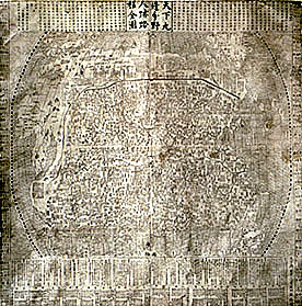
Complete Map of
Allotted Fields, Human Traces, and Travel Routes Within and Without the Nine
Frontiers Under Heaven Ming
dynasty (1368�1644), Chongzhen period (1628�44), dated 1644 Hanging
scroll, ink printed on paper; 124.6 x 124.6 cm Inventory number: 1/1644/14526 From
the late Ming period onward, Chinese scholars experimented with a number of
ways to combine cartographic knowledge dispensed by Jesuit missionaries with
traditional Chinese mapping conventions.�
One such example is this map drawn by Cao Junyi and printed in Nanjing in
1644. The
map showcases Ming-dynasty China at the center and indicates its two imperial
capitals of Beijing and Nanjing, thirteen provinces, the Great Wall, and
significant mountains and rivers.� The
source of the Yellow River is drawn in the shape of a gourd, while river
courses and coastlines are somewhat distorted since the map was not drawn to
scale.� Using assorted legends, the map
also includes the fu (superior prefectures), zhou (ordinary prefectures),
xian
(counties, which are provided with a brief account of their history), and wei
(administrative headquarters) throughout the empire.� In addition, the locations of tusi (aboriginal offices) in southern and
southwestern China are indicated.� The
text at the top of the map gives the title and an explanation of the countries
in the world. �That at the bottom
describes the two capitals and thirteen provinces, including their names,
population figures, and production and taxation figures for commodities, such
as rice, wheat, raw silk, processed silk, cotton, linen, money, horse fodder,
and salt; all the information is taken from the Da Ming yitong zhi (General
Gazetteer of the Ming Dynasty).� The
texts on either side of the map list the 29 strategic passes of the Nine
Frontiers and 33 foreign countries. |
 |