| |

Annotated Atlas
of Jiangxi Province
Ming
dynasty (1368�1644), Wanli period (1573�1619), undated, ca. 1600
Album
of 2 frontispiece leaves and 78 leaves of maps and corresponding texts; overall
dimensions of album: 35.2 x 30.0 cm; frontispiece leaves in ink on tangerine
gold-sprinkled paper, each leaf: 28.8 x 26.6�26.9 cm; map leaves in ink, color,
white pigment, and gold on silk; text leaves in ink on silk; each leaf: approx.
35.0 x 30.0 cm; each map: approx. 28.6�29.0 x 26.4�26.7 cm; each text: approx.
28.8�29.0 x 26.6�26.8 cm
Inventory number: 224/1600/9055
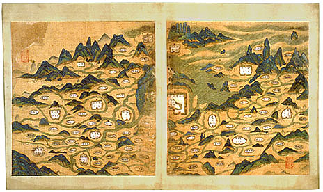
This
late Ming geographical work is the oldest extant atlas of Jiangxi but is no
longer complete.� It now contains 37
maps, including a general map of the province, 6 maps of the superior
prefectures of Raozhou, Fuzhou, Jianchang, Ganzhou, Ji'an, Yuanzhou, and
individual maps of 30 counties.� Names
of structures, such as schools, temples, monasteries, and pagodas, are in ink
within white-pigmented cartouches (mostly vertical but with a few horizontal
ones), while natural landforms, like mountains and peaks, are indicated in gold
ink set against rich mineral hues.�
Rivers and water bodies are not named on the maps, but the more
significant ones are mentioned in the explanatory notes, along with information
pertaining to the history, topographical features, strategic establishments,
and folk customs of each administrative unit.�
The overall map of Jiangxi on facing leaves functions as a schematic
layout of the administrative divisions in the province as well as a table of
contents, since each prefecture and county indicated would have been
represented by a more detailed single-leaf map and accompanying descriptive
text.
| |