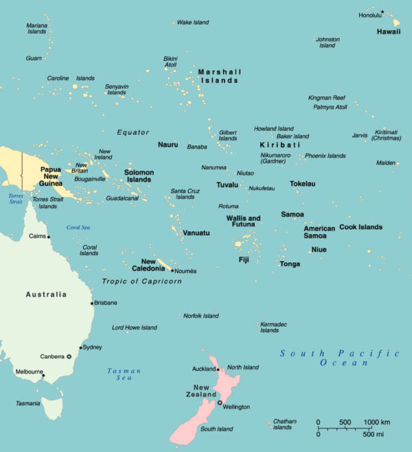
Geographical Origins of the Artists in the Exhibition
The Pacific Islands are geographically and culturally
divided into three groups: Polynesia, Melanesia, and Micronesia. The majority
of artists in the exhibition come from Polynesia.
Click on map
to see larger view.
Polynesia
The vast complex of islands and atolls within
the geographical triangle of Hawaii, Easter Island, and New Zealand.
The main archipelagos are Samoa, Cook Islands, and Hawaiian Islands.
Melanesia
The collective name for the archipelagos northeast of Australia: Papua
New Guinea, Admiralty Islands, New Ireland, New Britain, Solomon Islands,
Santa Cruz Islands, New Hebrides, New Caledonia, Banks Islands, and
Fiji.
Micronesia
The islands extending east from the Philippines: Marianas, Caroline
Islands, Marshall Islands, Gilbert Islands, Tuvalu.
An area strewn with islets, atolls, and reefs.
Fiji
An archipelago in Melanesia, consisting of approximately 800 islands
and atolls. It is said to have been the first stop of the voyagers who,
some 3,000 years ago, migrated to the mid-Pacific from Asia. The first
European sighting was by the Dutch explorer Abel Janszoon Tasman in
1643; it was subsequently visited by Captain James Cook (1774) and more
thoroughly explored by William Bligh (1789). Annexed by Great Britain
in 1874; gained independence in 1970.
Hawaiian Islands
An archipelago in northern Polynesia consisting of 8 inhabited
islands and 124 uninhabited atolls. Originally peopled by the Polynesians
about 500. Cook was the first European visitor in 1778 and named them
the Sandwich Islands. After they were annexed to the United States in
1898, they reverted to their indigenous name. In 1959 the islands became
the 50th state of the Union. Today, more than 80 percent of the population
is Caucasian, Japanese, or Filipino.
New Caledonia
A large island and a cluster of small islands in Melanesia. The island
may have been sighted by the French explorer Louis Bougainville in 1768,
but the first European to land on it was Cook (1774), who named it New
Caledonia because of its pine-clad hills that resembled Scotland. The
island was later annexed by France.
New Zealand
The largest and most southern landmass in Polynesia. Probably first
settled by voyagers from Tonga about 900. The first European sighting
was by Tasman (1642). In 1769 the northern and southern islands were
surveyed by Cook, who used them as a base for his three Pacific voyages.
In the 19th century, the islands were a frequent port for whalers and
sealers. The first Christian missionaries settled in 1814. With the
Treaty of Waitangi in 1840, the Maori chiefs ceded sovereignty to Great
Britain. In 1907 New Zealand became a dominion of the Commonwealth.
Niue
Niue was colonized by the Samoans in the 9th or 10th century A.D., but
the Tongans invaded the island in the 16th century. In 1774 Cook visited
the island three times, but he encountered hostility from Niuean warriors
and he called it Savage Island. It was named a British Protectorate
and was handed over to New Zealand administration. Niue became independent
in 1974, but it continues to operate in free association with New Zealand,
and the islanders hold New Zealand citizenship. It is one of the world's
smallest self-governing states.
Samoa
An archipelago in Polynesia consisting of Western Samoa (Palauli and
Upolu) and American Samoa (Pago Pago and Tau). The first European sighting
was in 1722, and it was subsequently visited by Bougainville (1768).
Torres Strait Islands
Situated in Melanesia between Australia and Papua New Guinea, the Torres
Strait Islands consists of more than 100 islands. The strait was discovered
by the Spaniard Luis Vaez de Torres in 1601 as a vital gateway to the
Pacific. One hundred sixty years later, Cook's Endeavour discovered
more of the islands. Pearl fishing began in 1868, and the islands were
annexed to Queensland, Australia's northern state, in 1878.